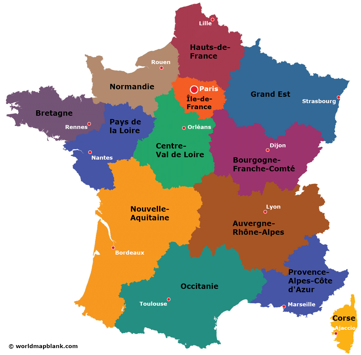

Do you need a labeled map of France? Download it here! All France maps on this page are available as free PDF files. We offer a map of France with cities as well as a France map with regions and a map of the departments of France. Click on the download links below each image to get your printable map of France in A4 or A5 format!
If you want to extend your collection of France maps, you can also download our France outline map. This black-and-white map is very helpful for memorization exercises and tests or exams. But it can also be useful for professional and personal applications, such as tracking your travels through France.
Finally, if you are looking for ready-made learning activities about the regions of France, check out our France map worksheets! They are perfect for teaching about the regions and cities of France and can be customized according to your needs. Get them now!
Metropolitan France (France métropolitaine or the European part of France) covers a total land area of 210,020 square miles (543,940 square kilometers). It includes mainland France (France continentale or Hexagone) and the Mediterranean island of Corsica. It has a population of approximately 65 million people.
Our first political map of France shows the regions of the European part of France. We offer this map in two versions. The first includes the regions with capitals and the national capital, Paris. The second French regions map only shows the regions without their capitals. Further below, we offer additional versions of a labeled map of France, and we also have a blank map of France.

In 2014, an administrative reform was passed to reduce the number of regions from 22 to 13. The new political subdivision became effective on January 1st, 2016.
The 13 regions of metropolitan France and their capitals include:
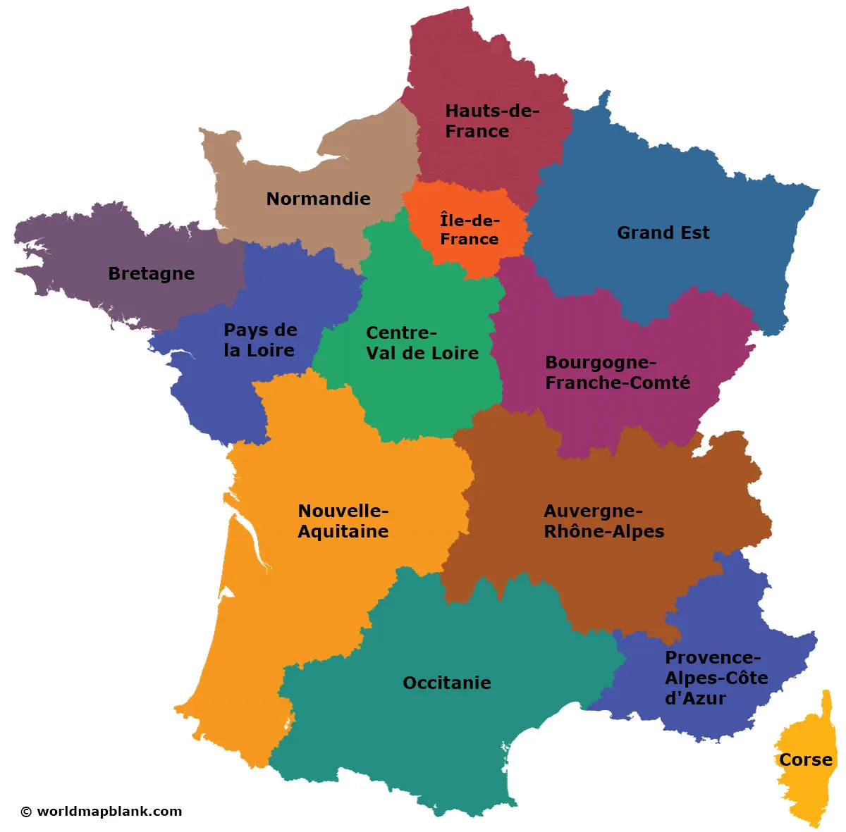
The following overseas regions can extend the French regions list:
Our France map with cities shows all the regions of France but also includes the major cities of metropolitan France. The cities depicted on the map are the capital cities of the French departments and regions.
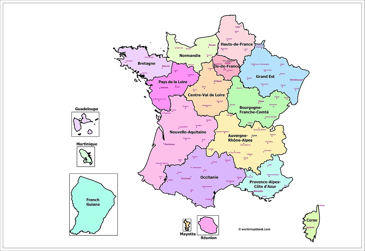
The most populated cities in France are:
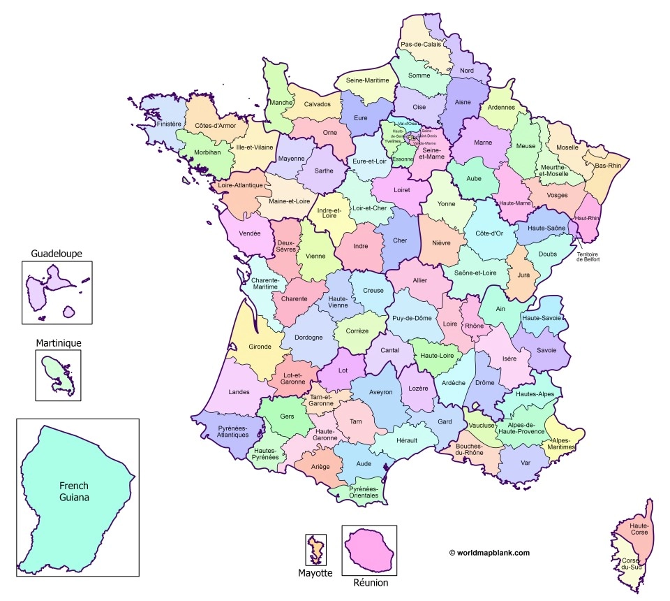
The departments (départements) are the administrative divisions of the French territory on the level below the regions. After several changes over time, there are now 101 departments total, 96 of which are located in Europe. These are coded by numbers in alphabetical order from 01 (Ain) to 95 (Val-d’Oise), whereas the number 20 is replaced by 2A (Corse-du-Sud) and 2B (Haute-Corse). The overseas departments are numbered from 971 (Guadeloupe) to 976 (Mayotte).
The following map of departments in France includes all the borders between the departments in the European part of France as well as the overseas departments.
France is famous for many things, such as fashion, wine, French cuisine, art, a long and rich history, and brilliant architecture – among many other things.
Some famous French people include Napoleon Bonaparte, Coco Chanel, Louis IV, Edith Piaf, Joan of Arc, and Charles de Gaulle.
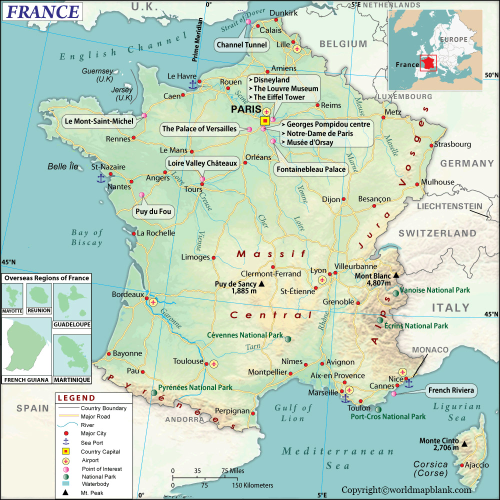
Among the most famous buildings in France are the Eiffel Tower, the Louvre Museum, Notre Dame Cathedral, and the Arc de Triomphe (all in Paris). But the Palace of Versailles or the Mont Saint-Michel belongs on the list of the most impressive buildings.
Our following map shows where France is on a Europe map and indicates the locations of some of France’s most important places of interest.
Download as PDF
The French culture has been influential all over the world for centuries. In literature, for example, one can find famous authors such as Voltaire, Victor Hugo, Emil Zola or Marcel Proust. In the arts field, France has given the world some of the greatest painters like Claude Monet, Paul Cezanne, and Pierre-Auguste Renoir.
In fashion, France is well-known for designers such as Coco Chanel, Christian Dior, and Pierre Cardin. The country is also renowned for its luxury goods, such as champagne and perfume.
The French cuisine is another area where France shines. Apart from classic French food like croque monsieur, foie gras, coq au vin, or bœuf bourguignon, French wine and champagne are also among the best in the world.
The neighboring countries of France are Belgium, Luxembourg, Germany, Switzerland, Italy, Andorra, Monaco and Spain.
Here is a link collection for additional interesting resources about France, the European Union, and the world and its continents. As with all our maps, they are free to download as PDF files and print.
We also offer geography worksheets for France and many other countries. Check them out!